

They’re building houses on the field.
Not in the field: the field has gone. On it, on the site that it once occupied. For a hundred years, it was a field. Before that, common land perhaps, before the village spread up the hill to encompass it. I don’t know.
The developers haven’t grubbed up hedges or cut down a woodland or demolished a historic building to create the space for the new houses. All they’ve done is levelled a hillside field which had been largely unused for 34 years.
We moved when I was nine. The new house was separated from the nearest street by a long, rutted driveway (whose potholes, no matter how often they were filled, always returned in exactly the same form) and from the rest of the village by a quarry1 and, directly in front of it, the field in question. Behind the house – to the south – was a steep whin-furred hill2 above which the sun barely rose in winter months.

That first summer – we moved in June – the field was full of crops. What crops they were I don’t know, other than that to us they had the softness and pliability of grass. At season’s end the field was full of monolithic cuboid bales (which the farmer would shout at us for clambering over).
That summer (and perhaps all the summers beforehand, I don’t know) local kids of all ages played in the field. The long grass converted it into a different world. We made tunnels through the grass; flattening it into broader or narrower channels through which we crawled, playing hide and seek, or ambushing each other by tying the grass in loops that caught a running foot. In the centre of the field where all the paths met was a vast plaza of flattened grass; a meeting point from which all points of the field were visible. Hours were spent in perfecting these hidden channels and creating new ones, or hidden ones whose start and end points were not linked from others: to get to these you needed to jump over the grass to find them. The field seemed to contain more space than its dimensions occupied.
Then the field was mown, and the bales raised. The field shrank overnight.
After that summer, it was left fallow. Ponies were kept there until recently. An electric fence was installed to prevent their escape3. But because it was much quicker to cross the field to get to school than it was to take the road, I risked the fence twice daily. Sometimes it got me – a snap that seemed to twist the bones in your finger all the way around – and sometimes it didn’t.
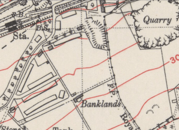
By coincidence, one of the houses at the bottom of the field belonged to my aunt and uncle. My route took me down the field, over the low wire fence at the bottom, and through their garden. The sightlines were clear and the distance sufficient that my cousins and I could pass messages from house to house just by leaning out of a window and shouting. No-one was disturbed, there was only a field in the way.
And that’s it. Since then the field has been a negative space; a memory; a pause or comma between streets. But enough to seal its fate. The houses are being built – though such is the height differential of the slope that there’s now a virtual cliff at the back of the site. In fact the gradient is such that you wonder that it was even worth the bother (the site foreman told my Mum that it was the most troublesome development he’d ever worked on). The houses themselves are social housing, which the country needs. There’s some local discomfort about this, but when I was growing up almost every house in the surrounding streets was a council house: all that’s happening is a belated attempt to mollify the logical consequences of Thatcherism.

From now on, the field will be a ghost: the memory of it will lie beneath the flats and houses.
The book From Place to PLACE by Common Ground is about parish maps: local communities creating alternative, subjective maps of their area which can give precedence to parts that an “objective” map wouldn’t. My son’s school has recently been undertaking a project along similar lines in the town where we live. In the book, people are asked to consider not just what it is they treasure about their “parish”, but also what they would miss if it were to disappear (the direct implication being: to make way for new buildings). If I had ever to contribute to such a map of my home village – which I left for good more than twenty years ago – it wouldn’t have included that field for the simple reason that I wouldn’t have assumed there was any threat to it; nor did I appreciate it’s quiet value. Now I do, but it’s too late.
1 Home to the peregrines – or the descendants thereof – that Kathleen Jamie wrote about in Findings.
3 I once managed in a particularly harsh winter to sledge from the side of my house, down the drive, down the banking, down the field and crashed into the fence at the bottom: 200 metres at least. It was magic.
Vintage maps reproduced with the permission of the National Library of Scotland
Other images copyright Google
